


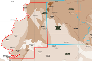
The Northern Territory Geological Survey (NTGS) has commenced one of its largest ever regional-scale airborne geophysics programs across the Top End, with two major Airborne Magnetic and Radiometric (AMR) surveys now underway. Together, the NTGS Pine Creek and Cape Scott AMR surveys will acquire modern, high-resolution data across almost 47,000 km2 , significantly improving magnetic and radiometric coverage to 200-m line spacing across the western Top End. The new datasets will enhance understanding of the region's geology and provide explorers and researchers with publicly available geoscience information to support future exploration.
The NTGS South Georgina Ground Gravity Survey will also kick off shortly. All three Northern Territory Government funded surveys will be completed and released in 2026-27.
Pine Creek AMR Survey
Covering more than 22,000 km2, the Pine Creek AMR Survey extends from Litchfield National Park in the west to Kakadu National Park in the east; and from Djukbinj National Park in the north to Katherine in the south. The survey will deliver modern geophysical coverage across some of the Territory's most prospective polymetallic terranes.
Cape Scott AMR Survey
Covering almost 25,000 km2, the Cape Scott AMR Survey extends from the western coastline to Litchfield National Park; and from the Finniss River in the north to the Fitzmaurice River in the south. The survey will provide new geophysical data across a largely underexplored region of the western Top End.
These two surveys will provide continuous high-resolution coverage across prospective areas, including the Bonaparte Basin, Fitzmaurice Basin, Carpentaria Basin, Victoria Basin, Daly Basin, Birrindudu Basin, Pine Creek Orogen and McArthur Basin. Industry infill is increasing resolution to 100 m line-spacing in selected areas. The following 1:250 000 map sheets are being covered or partially covered: ALLIGATOR RIVER, CAPE SCOTT, DARWIN, FERGUSSON RIVER, FOG BAY, KATHERINE, MOUNT EVELYN, PINE CREEK and PORT KEATS.
The NTGS Pine Creek and Cape Scott AMR surveys are funded through the Northern Territory Government's Resourcing the Territory program and delivered in partnership with Geoscience Australia. The surveys build on the recent NTGS Pine Creek and West Arnhem ground gravity surveys and complement the framework geology studies currently being undertaken by NTGS across the Pine Creek Orogen.
To find out what else NTGS has planned for 2026, visit Resourcing the Territory (current) | Resourcing the Territory