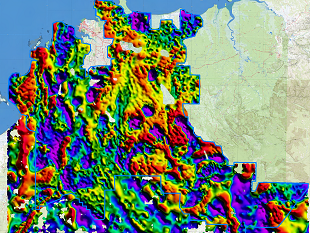
One of the last areas in the Northern Territory to be upgraded to a modern standard of gravity coverage has now been completed. The Pine Creek region was previously covered by regional scale ground gravity data at 11km spacing as part of the Australia wide gravity data program acquired by the Bureau of Mineral Resources in 1967. The NTGS Pine Creek Ground Gravity Survey commenced during field season 2024 and is now complete, covering more than 40,000 square kilometres, spanning from the northwest coastline to Kakadu National Park in the east and southwards to Katherine. Resolution is improved from historic 11km spacing to station spacing ranging from 500m to 4km.
Funded through the Northern Territory Government’s Resourcing the Territory program, the Survey aligns with the key objectives to drive exploration success through improved geophysical data and to accelerate resource development in established mineral regions. The Survey received significant industry support, with more than one-third of the gravity readings financed by private sector contributions. Geoscience Australia is managing the contract in partnership with NTGS.
The final data is now available for download via GEMIS.
Ground gravity acquisition will now continue westward as part of the NTGS West Arnhem Ground Gravity Survey.
DISCLAIMER:
The Northern Territory of Australia give no warranty or assurance, and make no representation as to the accuracy of any information or advice contained in this publication, or that it is suitable for your intended use. You should not rely upon information in this publication for the purpose of making any serious business or investment decisions without obtaining independent and / or professional advice in relation to your particular situation. The Northern Territory of Australia disclaim any liability or responsibility or duty of care towards any person for loss or damage caused by any use of, or reliance on the information contained in this publication.
LICENSING:
Creative Commons Attribution 4.0 International (CC By 4.0). Please observe and retain any copyright or related notices that accompany this material and give attribution to: Northern Territory of Australia (NT Geological Survey) and the Commonwealth of Australia (Geoscience Australia), 2024.
The data package consists of:
- CSV format file containing the gravity observations
- Grids of elevation and Bouguer Anomaly (including 1VD)
- Geotiff's of the stations, elevation and Bouguer Anomaly (including 1VD)