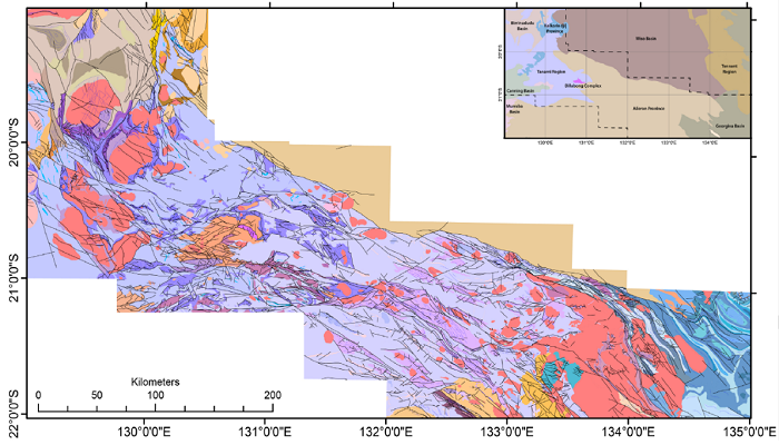
DIP035: Geological interpretation and structural analysis of the northwest Aileron and southwest Davenport provinces comprises a report detailing results from a co-funded, collaborative project between the NTGS and CSIRO along with solid geology GIS, a suite of geophysical images and the supporting geophysical data.
The work involved processing, enhancing and interpreting the 2019 NTGS Mount Peake-Crawford airborne magnetic and radiometric survey to construct a solid geological and structural map of parts of the MOUNT THEO, MOUNT SOLITAIRE and LANDER RIVER 1:250K map sheets, and the entirety of the MOUNT PEAKE and BARROW CREEK 1:250K map sheets. The work aimed to provide greater detail on structural relationships across the region, improve mapping of key lithological units and provide insights into areas that would benefit from further stratigraphic, metamorphic and geochronological studies.
DIP035 encompasses part of the northern Aileron and southwest Davenport provinces and seamlessly links with the recent Tanami Region Interpretation completed in the preceding DIP021 and DIP022: NTGS-CSIRO project, Aeromagnetic interpretation of the Tanami Region. Together these projects create a seamless geological interpretation stretching across more than 600 km from the Tanami Region bordering Western Australia to below the Tennant Creek region.
Request DIP035 via the 'Add to Request' cart in GEMIS.