The CSIRO-NTGS McArthur Basin Project: Geophysical data, interpretation and models was produced as part of a 3-year collaborative project co-funded by CSIRO and the Northern Territory Geological Survey. The project focused on the southern McArthur Basin which is located in the northeast of the Northern Territory. The southern McArthur Basin is considered highly prospective for sediment hosted base metals and contains the McArthur River and Teena deposits.
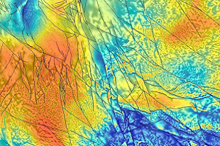
A structural and geological interpretation of the southern McArthur Basin including forward modelling of potential field data was undertaken as part of this study to improve understanding of the regional structural architecture, sub-basin development and tectonic evolution of this area. Digital Information Package 020 (DIP020) provides GIS format lithological and fault event interpretations, processed geophysical data and imagery and georeferenced figures for all models.