Digital Information Package (DIP) 033 details results from a co-funded, collaborative project between the NTGS and CSIRO to collate existing open source airborne electromagnetic (AEM) data sets within the southern McArthur Basin, document system characteristics, and model these data to produce maps of subsurface conductivity.
Data was compiled from forty-four surveys acquired using 10 different AEM systems and includes:
- Individual survey locations in GIS format
- Quality controlled AEM data
- AEM system characteristics
- Transformations of AEM data to CDI products using EMFlow
- Full non-linear inversion of selected AEM datasets.
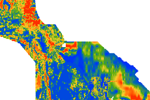
The area covers the southern McArthur Basin, which hosts the McArthur River and Teena Zn-Pb-Ag deposits and is highly prospective for base metals. The results highlight the subsurface conductivity structure across the southern McArthur Basin for areas covered by the historical AEM data sets. Where the AEM data sets cover parts of the Barney Creek Formation, the modelled AEM data show elevated conductivities and where present in the southern McArthur Basin they effectively map the sub-basin structures. The modelled AEM data is able to supplement structural information derived from other geophysical data sets highlighting faults and shear zones.
Due to its large size, DIP033 can to requested through GEMIS 'add to request'.