


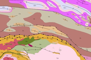
The BLOODS RANGE 1:250 000 mapsheet covers part of the western Northern Territory and include portions of the western Amadeus Basin and the northern Musgrave Province. The Musgrave Province portion of the area consists of Mesoproterozoic felsic rocks of the Pottoyu Granite Suite and volcanic and metasedimentary rocks of the Tjauwata Group. On BLOODS RANGE, The Tjauwata Group is unconformably overlain by Neoproterozoic to Palaeozoic sedimentary rocks of the Amadeus Basin.
Three major tectonic events shaped the rocks of BLOODS RANGE. Crustal extension during the Stenian Period was associated with deposition of the Tjauwata Group, followed by two periods of compression during the Petermann Orogeny and subsequent Alice Springs Orogeny. These events folded and faulted the rocks, creating the characteristic structures seen today in both the Amadeus Basin and the Musgrave Province.
Although exploration in the area remains limited, the rift successions of the Tjauwata Group in the southern part of BLOODS RANGE are considered prospective for both base metals and precious metals. The region also holds petroleum potential, as the Ordovician strata that host oil and gas in the nearby Mereenie field are known to extend into BLOODS RANGE. In addition, Cenozoic evaporite deposits at Lake Neale are broadly similar to those considered as potential potash resources in other parts of central Australia. BLOODS RANGE remains an underexplored area with significant geological prospectivity.
The second edition map series, replaces first edition mapping completed in the 1960s and incorporates modern understanding of Amadeus Basin stratigraphy and structure. The mapsheet integrates with neighbouring Amadeus Basin mapsheets, including the recently released LAKE AMADEUS 1 :250 000 map series.
Download the mapsheet and GIS GEMIS: Bloods Range , Northern Territory: sheet SG5203
Download the explanatory notes GEMIS: Bloods Range, Northern Territory : explanatory notes