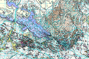
Detailed mapping and analysis have provided critical insights into the complex geological history exposed in the HUCKITTA map area, located approximately 250 km northeast of Alice Springs.
This prospective area encompasses parts of the poly metamorphosed and deformed, polymetallic Aileron and Irindina Provinces, the relatively unmetamorphosed and faulted Georgina Basin. The study integrates geological, structural, geochronological, isotopic and geochemical investigations with geophysical data. The result is a comprehensive understanding of the region’s dynamic geological evolution spanning over 1.8 billion years.
In addition to deepening scientific knowledge, the study highlights the region’s significant resource potential, host to the polymetallic Jervois deposit, molybdenum–tungsten Molyhil deposit, orthomagmatic nickel–copper–platinum group elements and the fluorite and barite bearing Oorabra Quartz Reefs. In addition to providing a new stratigraphic and structural framework, areas where intrabasinal folding and faulting are associated with localised mineralisation, including lead-zinc, copper, and epigenetic gold-copper systems are identified. The revised Huckitta 1:250 000 geological map and explanatory notes provide a modern geological framework that provides information and context to the known mineral deposits and prospects thereby highlighting this prospectivity of this relatively under explored area
The HUCKITTA Third Edition 1: 250 000 geological map, GIS and explanatory notes can be downloaded via the following GEMIS links:
HUCKITTA Third Edition 1: 250 000 map and GIS
HUCKITTA Third Edition Explanatory notes