The Birrindudu Basin is an underexplored region of the Northern Territory that is highly prospective for mineral and energy resources. Considered a part of the greater McArthur Basin, the Proterozoic rocks are similar in age to those prospective for mineral and energy commodities in the McArthur Basin, South Nicholson region and Mount Isa Province to the east.
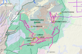
The Northwest Northern Territory (NWNT, L214) Seismic Survey comprises a total of 900-line kilometres over four lines. The deep crustal seismic data was collected in 2023.
The raw data can be requested from Geoscience Australia's website or through Geoscience Australia's product catalogue.
View the location of the Northwest Northern Territory seismic survey.
For more information on the project visit, Officer–Musgrave–Birrindudu | Exploring for the Future | Geoscience Australia (ga.gov.au).