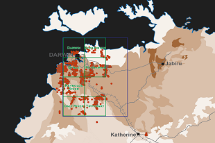
The latest release comprises legacy geo-located data digitally captured from reviewing more than 700 company reports. This data is comprised of over 17,700 drillhole collars, 123,000 down-hole samples with geochemical results, and around 44,700 surface samples (stream sediment, soil and rock chip) that have associated geochemical assays.
The legacy exploration data program continues its focus on the Pine Creek region. Capture of the remainder of the Darwin 1:250,000 map sheet is in progress and will plan to be released later in 2024. The total legacy exploration data released in the Pine Creek region now includes more than 27,000 drillhole collars, 190,000 drillhole samples and 114,000 surface samples with associated geochemistry results.
The digitisation of the legacy data is providing explorers with immediate access to a complete and spatially located dataset of all historic drilling and geochemistry in the area. This is an important pre-competitive dataset to allow industry to rapidly assess and interpret past exploration in the area.
For the latest release of NT surface sample geochemistry and drillhole locations download in MapInfo tab, KML, ESRI shapefile and csv file formats from the STRIKE website.
The latest data is also included in the latest version of DIP001: Northern Territory geochemical datasets available through GEMIS.