The Northwest Northern Territory Seismic Survey (NW NT Seismic Survey) was acquired from August to September 2023 as part of the Australian Government's Exploring for the Future program and the Northern Territory Government's Resourcing the Territory program.
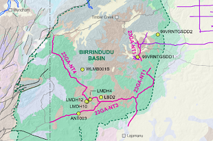
The collaborative survey aimed to comprehensively map the subsurface geology of a significant, yet largely underexplored region in the Northern Territory. The survey successfully acquired approximately 846 kilometers of high-resolution seismic data across four seismic transects: 23GA-NT1 (comprising 54.5 km and 184.5 km in two separate sections), 23GA-NT2 (112 km), 23GA-NT3 (221.46 km), and 23GA-NT4 (274.2 km) and covers an extensive area of the Birrindudu Basin, Kalkarindji Suite, Tanami, and Wolfe Basin.
Geoscience Australia states "the findings from the NW NT Seismic Survey will advance our knowledge of Australia's geology and unlock new opportunities for exploration and economic development in the northwest Northern Territory".
The processed data and report can be downloaded through Geoscience Australia's product catalogue.